15 December, 2007

Eli Britain Clark has Joined Our Family


So here's the scoop: On Thursday afternoon after about an hour of painful contractions, which were about 7-8 minutes apart, I told Joshua we were going to the hospital to get checked. Turns out I was dialated to a 6+ and Eli was so good and obedient that he came out about an hour and a half later. All told, labor was about 5 hours start to finish and went very smoothly - much to our satisfaction! Eli was born at 5:43 pm on Thursday 12/13/07. He weighed 7 lbs. 6 oz. and was 20 in. long. He seems to be a very alert little guy and is always hungry! He ate more his first night than German ate his first week of life. We were a little afraid of how German would react to little Eli, but it seems that German loves his little brother very much. Eli has received many kisses, high fives, and burping pats from his brother. I think they'll be good pals. Joshua is doing well and seems to be losing all of his weight rather quickly. I'm also hanging in there and trying to take my recovery slowly.

02 December, 2007

Thanksgiving


It was great to see all of you over the holiday break. We really enjoyed the cheesy movies ("Leftovers"), conversation, food, but mostly the company. We really get to missing our family. There's not much to report about the last week, except that #2 is taking his time coming into the world! We also arranged to fly into SLC for Christmas and then drive to Boise, so in other words, we should be good to go to have the baby's blessing on Sunday, the 23rd. We'd love to have you all there, but we also understand that you all have lives and obligations, so we will understand if things don't work out. Here are a couple of pictures from our trip - enjoy!


07 November, 2007

West Jordan - December and upcoming

We used to have a post on early November, but it was really whiny, so I have now replaced it with this.
Various of you were in West Jordan, for Thanksgiving. Nice to get together.
Just before Thanksgiving, there was a trip out to Livermore. A kitchen remodel just completed there.
Upcoming events for December -----
02 - 07 December 2007 JBClark in Seattle WA to train the folks at FRB
07 - ?? December 2007 GGClark to Phoenix by car depending on new arrivals
08 - 14 December 2007 JBClark by air to wherever GGClark has ended up, for drive back to SLC
19 - 21 December 2007 JBClarks in West Jordan
22 - 24 December 2007 Clarks to Boise for family gathering for projected JGClark son #2
24 - 31 December 2007 Clarks in West Jordan


02 November, 2007

A Bunch of Pictures of Halloween! (Orange and Black Costume Day)


We had an eventful week of spooky fun and I'm sure German still has no clue what Halloween is all about - oh well! We went to "Boo at the Zoo" last Saturday and got to see some of the animals dressed up and other animals ate pumpkins (but mostly because there were dead rats inside - gross!). We also went to our ward's carnival that night - German enjoyed playing the little games and winning the prizes. Then Monday night we carved pumpkins at a friends house for FHE. Of course we went trick-or- treating Wednesday night. I think it was more fun for Joshua and I to relive childhood memories than it was for German, especially because he didn't even know what you were supposed to do with the candy. By the end of the night I think he was figuring it out and kept asking for "more." The best news is that my husband is the most clever person at Centex Homes. He won first place (and a nice monetary reward) in the dress up contest. You can see in the pictures that he was "ThinKing outside of the box!" The best part was that we came up with the idea about 11:00 pm the night before and didn't have to pay a dime for the entire outfit! Notice that he's wearing my maternity pants and nylons and thanks to mom for her handy work on the shirt several years ago.

Aside from Halloween, we are all doing well and enjoying the cooler temperatures (only in the 80's) and beauties of an Arizona fall, which is more like spring! The baby is growing well and should be here in about six more weeks.


29 October, 2007

West Jordan - The geezer abroad in Missouri

The geezer took two trips for work during October.
One was to some boring place in Columbus, Ohio over LDS General Conference weekend.
The other one was to FRB in Kansas City, Missouri and there was actually a couple of small spots of after-work time. So here we go with some photos of places in and around Independence.
The second of the two quick trips was to the Clay County Jail in Liberty, Missouri.
I didn't know much about the Missouri church history sites, so there were some surprises for me, like this one..
The original Liberty jail was built circa 1830, just before the church folks got to Missouri.
It was used for Smith&co in 1838, for another for 50 years as a jail, and another 8 or so years for ice storage, before being demolished circa 1900. So it was long gone until the mid 1900s when the Church bought the property and built the exhibit shown in the next several frames.....


This frame is an overview showing the entrance to the LDS Visitor Center built on the original site to house a full-scale replica of the jail. The jail replica is housed in the octagonal enclosure in the near distance at far right. This frame is inside the dome and shows the upper of the jails two floors; Entry to the jail was through the door on the far side of the upper floor shown above. Apparently it was built in more than 1 phase ...The first phase was a log cabin with rough hewn logs (the logs in the replica are not original) approximately 1 foot thick. The county then decided that more reinforcement was needed, so the 2 foot thickness stone walls were added. The stone was intentionally built 1 foot recessed from the inner wood structure and the space was filled with loose rock. There were two grates - one on each side - for ventilation. This frame shows the lower floor of the facility is apparently where the detainees were housed, at least our detainees of interest: Joseph Smith, Hyrum Smith, Lyman Wight, Alexander McRae, and Caleb Baldwin. Sidney Rigdon was also detained initially but released early. About 1/2 of this lower floor is below ground, and entry is through a trap door from the floor above. It is about 6 feet high, which must have cramped the style of the taller occupants. No lights,no fireplace, no sanitation, ventilation through an open grate on each side of the jail. Did I mention crummy food. What a great place to spend 4 months confinement. This is the site of origin of D&C Sections 121-123. The ventilation grates were mentioned earlier. This frame is close-up of those. Liberty is about is 10 miles north of Kansas City on I-35.


The first of the two trips was to Independence, Missouri (an adjoining town 7 miles due east of Kansas City). The Independence church history site is a much busier place as to ownership of various pieces of property. The main area consists of a four-block area shared by various denominations (1/2 mile west of downtown Independence). (1) NW section - Empty future Jackson county temple site, now owned by Church of Christ (Temple Lot); (2) SW section - Community of Christ Auditorium; (3) SE section - LDS Church Independence Visitor Center; (4) SW section - Community of Christ Independence Temple


This frame is an attempt at overview of the 4 block area - sorry about the lighting. This is a view from the west side of the NorthWest block. In the foreground is (1) the empty future temple site (or "temple lot") dedicated in Aug 1831 by Joseph Smith. Background left is (2) the Church of Christ (Temple Lot) meetinghouse and headquarters facility, and far background center is (3) the Community of Christ Temple. The remaining parts of the area are (4) the Community of Christ Auditorium, off camera foreground right, and (5) the LDS Church Visitor Center off camera backgound right.


This frame is a reasonably lighted (taken earlier) view of the Community of Christ Auditorium - the approximate though much larger counterpart of the Mormon Tabernacle in Salt Lake. It is about the size of the Marriot Center. The northwest corner of the LDS Church Independence Visitor Center building is the foreground on the right, for an idea of the design style the church used - a lacy vaulted arch design. This frame is a better lighted and closer view of the Community of Christ Temple. So much for the photos, now a couple of other interesting observations from my stroll.... There are at least 2 other derivative denomination within a couple of blocks of the central church area of Independence ... some I noticed buildings for were: (1)The Remnant Church of Jesus Christ of Latter Day Saints, which separated when RLDS changed to CofC


The birthplace of Harry S Truman is 3 blocks west of downtown (extreme left distance of this view), and the Truman Library complex, where David Clark is on staff, is 2 miles north of this area.


One final Really Wierd thing I stumbled onto while talking to Mom on the phone.... Egbert J Gates and Dorothy Vernon Stiles were married at the Grace (Episcopal) Church at 415 West 13th Street in Kansas City, Missouri. The FRB site is at 27th and Main street - about 14 blocks away. The church is still there and is now called Grace and Holy Trinity Cathedral. It even has a web site. (http://www.ghtc-kc.org/)

This is a photo I got from the web site. I went over there the night before I came back and talked to Mother on the phone, described, took pictures, etc.


28 October, 2007

MIdvale checking in

Hello family, all is well in Midvale. We have survived the resurfacing of our apartment complex parking lots. We evacuated to West Jordan for two days, to avoid the hassle of finding open "visitors" spaces while our section was being done. We returned home only to find a notice that our section had been rescheduled due to weather conditions. Fortunately we were able to find visitors spaces during the rescheduled time, even if it was a bit more of a walk. We also received a nice flyer today with a phone number of the security people that patrol the complex, so we can call in a noise complaint the next time the folks in the neighboring building have a drunken party at 4:00 am.

Marilyn's temp agency assignment at LDS hospital is coming to an end, as the new Intermountain Medical Center in Murray is opening this week and all the staff are being reshuffled. Cottonwood Hospital is closing and transferring all its patients to the new hospital. There was no promise of the assignment going past the end of October, though we won't be surprised if we get a call saying they want her to come back. We'll see how things go with different assignments from the agency.

We're keeping busy with some reorganizing of our apartment and stored things, and Marilyn has been back at the sewing machine after a needed break. (That wedding dress took a while to make.) She did a Halloween costume for a coworker's child on commission, and the little Pokemon outfit is done now. The sewing machine at home decided to stop cooperating midway through the project, so we had to go the North house to finish it off. The little cap and shirt turned out to be cute.

01 October, 2007

West Jordan - assorted news bits

  • From Logan .... Ruth Bragg is engaged (to Justin)
    We are informed that the wedding is planned for 12 January 2008, 9 am, Logan, UT (Temple). We recently provided addresses for announcements.

24 September, 2007

West Jordan visits Mesa

Hello again ...... West Jordan went wandering over the weekend to get a look at Mesa.
CENTEX Homes office in Scottsdale -
(1) Front view (with signage)
(2) Staff entrance


The apartment on Val Vista in Mesa -
(1) Entry/Dining area
(2) Kitchen, with Julie


More apartment, more people
(1) More Living room with GMaC and German
(2) Looking toward halls/bedrooms from Living room, with Joshua/Julie/German


More apartment, some people
Parents room, desks and stuff


Does anyone remember Papago Park ???
From a long time ago when you were 6 or 4 or 2 or 1/2 .... well, yesterday.
(PHX Zoo, Desert Botanical Garden and these prominent rock formations are in Papago Park)


The idea for this trip came from .... who knows where.
We flew Friday and Monday.
The JoshuaGClark lodgings are in Mesa about 10 miles straight East on the Superstition freeway (US 60)
from our Tempe InnSuites lodgings of long ago (which are still there) on Baseline and I-10.
The GParents stayed 1 block from the lodgings of yore at a more recent Marriott property with a nice price.
Mom is still recuperating from the jarring encounters with TSA (any encounter with TSA is jarring).

23 September, 2007

23 September 2007

Greetings from BYU!

Well, it's been an interesting couple of weeks. I took the GRE on the first of the month, and am reassured by my boss that my scores are good enough (I'm still a little doubtful, but that may just be my own silly perfectionism kicking in). Not a terrribly exciting experience; but I'm still debating whether I 'want' to retake it. Not inclined to give ETS another $140(??!).

I'm just starting my last fall semester at BYU, and taking some very interesting, albeit taxing (and there are only 13 credits' worth...!), classes: Humanities of Asia, Mayan Art and Culture (one of two capstone courses for my major), Greek New Testament (John, and possibly Mark if Prof. Duckwitz decides we've got it too easy), selections from Herodotus (the 'Father of History,' naturally in the original Greek), and private organ lessons (last requirement for my music minor). I'm also auditing Turkish (!!!), which I'm really enjoying; a classmate and I (who also happens to be a former colleague from Special Collections) are also helping the professor's wife practice/learn English (which means we also get to practice our two words of Turkish).

Since June, I've been serving on the Temple Committee in my ward; unfortunately, though, I haven't gotten a chance to do much of anything yet (bishop said there was a guy in his ward who had wads and wads of family names to be done, but said individual has yet to get back to him with the details. Guess I should have just scheduled things anyway. Oh well.) At the beginning of the semester, though, I was called as the Enrichment counselor in one of the two Relief Societies in our ward (there are twice as many women as men in our ward, so they decided to split us into two sections so that every sister would have a chance to have a calling). I have yet to be released from the Temple Committee (replacement still pending). The day my presidency was sustained, we were asked to speak in sacrament meeting the following week, and, amusingly enough, I seem to be a lot more memorable to the ward now - might have something to do with the fact that I dragged my little obsession into it.....

I bet that's more than most of you have 'heard' me say my entire life.....

Love you all!

10 September, 2007

West Jordan - 8 Sep 2007 - summary of our screwed up trips

Hi from West Jordan
What this post might have consisted of had we not been interupted
by vehicle mechanical issues was a report of a trip to Fish Lake and then Bluebell Knoll.
As it was we did not get to either place - at least under our own power.
We did get a short glance of part of Fish Lake when the tow vehicle went up
there to pick up a second vehicle for tow back to Richfield.
Here is all we will see of Fish Lake until next season:


The summit we were planning on was Fish Lake High Top (elevation 11633)
To get up there, we planned hike up past here --->
The paved highway shown in the foreground is Utah Hwy 25, which is 7 miles long and
connects Fish Lake with Utah Hwy 24.
Our 2005 Safari developed a sudden leak in the oil cooler line almost exactly at the intersection of the highways and sprayed all our crank case oil all over Hwy 24 just as we were to have turned, so we overshot the turnoff by about 1 mile. Had we not missed our turnoff, we presumably would have lost our oil during the first mile of Hwy 25.
The turnoff is on an uphill grade along Utah 24 anyway, so we would have been on a strong uphill grade either way. So, The rest of the day was spent ....
..... Being towed 31 miles to Richfield
..... Finding a repair place
..... Finding a new oil cooler line
..... Getting the line replaced in time to head back to Salt Lake for the day.
We have been having screwy mechanical issues with our 2005 van all summer long;
This is a little disturbing because it was supposed to be our strong vehicle. Oh well

While we are on the topic mangled trips, here are some shots of Aspen Grove trail on Timpanogos
This was a missed summit attempt with Amanda. Check out the pretty waterfall.

The original idea was an offer to Amanda to help her try out an overnight pack trip to Timpanogos Summit via the
American Fork (Timpooneke) trailhead. I got spooked in the face of the trip launch complications and started us in Aspen Grove instead.
Don't anyone else try this at home....
The terrain is all just like what you see in front of you for about 4 miles and it is "all or nothing"
with no place up trail to put a tent. That's why no one does Aspen Grove as a 2 day, and why American Fork trail is sometimes done as a 2 day - there are more level spots spread along the route.
Amanda gets a rain check for this trip. She tells me that the messed up trip was nevertheless very productive as a guage of her own capabilities on equipment carries, terrain evaluation, site selection, night hiking, and rugged minimalist camping. She claims she had a blast and wants to have another go. Hence the rain check.

Here are two shots she had me take from our highest uphill travel point. This is actually a 2 part pan shot, from left to right.
This is further illustration of suitability of Aspen Grove for an overnight unless Emerald Lake is where the overnight stop is. This is all straight up: 4850 feet in 5 miles According to the topo map, the straight line distance is only about 2 miles, not counting contours.
The contours in this case are close together, meaning steep terrain and therefore switchbacks. So the actual trail distance is 4 miles in switchbacks to bring the entire route total to 7 miles from Aspen Grove to summit.
The American Fork side is longer by map, but is also more level, so there are many more places to stop over. We have tried this before and it works.
So much for messed up trips this season.....
Even with that we managed to get out a bit this summer:
(1) Catherine Pass hike, Dad alone, 14 June
(2) Willard Basin/ Willard Peak recon trip, Dad alone, 5-6 July
(3) Sunset Peak and Catherine Pass, Dad/Amanda, Mom/Melissa at Lake Mary, 21 July
(4) South Tent summit, Dad and Amanda, 28 July
(5) South Tent summit, Dad, James, Amanda, (Mom, Marilyn at trailhead) 18 August
(6) Bluebell Knoll summit, Mom and Dad, 21 August
Possible trip list for other seasons:
Incomplete first ascents:
(1) Willard Peak - (Weber county)
(2) Fish Lake High Top (Sevier county)
(3) Eccentric Peak (Daggett/Uintah) - Accessible from Spirit Lake
(4) Boxelder Peak - Wasatch front
(5) Bull Mountain (Boxelder)
Possible repeats:
(1) Timpanogos 2 day - Amanda
(2) Mount Nebo (Utah county) - Dad
(3) Bluebell Knoll (Wayne county) - James/Marilyn

07 September, 2007

West Jordan - 21 August 2007 - Bluebell Knoll

Gayle Clark, noted mountaineer, standing in front of the sign indicating the location of the terrifyingly steep and precarious ...
Bluebell Knoll (11322). It is in the medium distance behind the sign.
A lovely day out. Long drive, short hike.

Gayle Clark descending from Bluebell Knoll summit -
which we had to hunt around in the woods a bit to find.

PPS

Hey, Joshua and Julie, We'd love to see the pictures of German. The address you provided did not work with the only password I have; have I misunderstood something? Thanks for the help - and I always need lots of that! Though I did do this "all by myself" (after your Dad coached me!)

"Tidal Tomato Wave"

Hey, Bodies! Kilroy was here! So were tomatoes; taught a canning mini-class at the church kitchen twice this past week, so I have one more case of the things in the basement hall. Steve and Maurine (he has a beard again, and looked better to me than he has in a while) seemed to enjoy the garden corn and tomatoes while they were in town. But then they got a double dose 'cause Jared and Margie Brown had them over for dinner one night after a bunch of Jorgensens had congregated at Aunt Eleanor's one Sunday evening. Jared brought lots of his garden produce to Aunt Eleanor's place, and was distributing it liberally among the visitors (squash, odd-looking Armenian cucumbers, corn, and the like). Last Monday, Dad and I went with Steve and Maurine to the Church History Museum and the Family History Library; I think they enjoyed the day. Your Dad and I worked in the yard week before last, and cleaned the carpets; I did the livingroom and hall, and he spent over an hour doing the stairs for me. I really appreciated the help, and it was fun to work together. As I was unloading the stuff last night from the car after the second canning mini-class, I heard a noise in the pine tree next door (by the cars). I looked up the tree in time to see a small raccoon peering down at me. I hope it won't get into the apples still on the tree; I've got enough to do some more applesauce this fall. We already picked all the corn; they're notorious for going after that. Anybody need some prunes? How about cherry tomatoes? Enough with the garden talk. Love to you all. It was great to get together at the airport, if only for a shorter visit.

Oops, I forgot.

I'll probably do this alot; sorry. Last Sunday evening, Steve and Maurine and your Dad and I went to visit Jeff and Robin White. They now live at about 4400 South and 4100 West. Robin told us that they are expecting child 3 in February. They have a cute 4-year-old named Rebekah and a cute 2-year-old named Joseph, both of whom were very well behaved, I thought, while we were there. And then we found out from Maurine the following Tuesday after they returned to Livermore that Ruth Bragg is engaged, to the particular Justin whom we met on one trip north last spring for Ruth's graduation from USU in aerospace mechanics (or such like; she works on airplanes). Ruth and Justin were sitting on the couch poring over a book on airplanes for at least an hour and a half while we were there. He's about 6' 6'' tall, kind of a "gentle giant". (My father gave me a book when I was a child entitled, The Gentlest Giant and Other Pleasant Persons.) I believe he lives in the area with his family, like she does, but I don't remember what he does for work. Ran across a word in Talmage I hadn't heard in a long time: trenchant. Had to look it up. 'Bye, Y'all.

Our Trip to California

Hello everyone!

We, the Josh Clarks, went to sunny California over the Labor Day weekend. It was a lot of fun and very relaxing, especially compared with the weekend before when we were in Boise for Julie's 10 year high school reunion. If you'd like to see a video of German at the beach you'll have to check out our family blog. I had good intentions of posting it here as well, but it took so long that to post it once I said forget it! (our address: joshuagclarkfamily.blogspot.com) We were also able to spend some time with Uncle Nick. It was nice to get to know him better and especially for he and German to meet. They hit it off right away. German even started saying, "Uncle Nick," although it sounds nothing like it! Hope you're all doing well.

02 September, 2007

Midvale- Sept. 1, 2007

Greetings from James and Marilyn! We just enjoyed a pleasant evening with the parents, Amanda, and Stephen and Maurine Clark from Livermore at the Owensboro homestead. Apparently we can call Stephen "Uncle Beard" if we get tired of his regular name. Marilyn received a lesson on how to cut men's hair from Mom Clark and used James as the guinea pig. She has prior experience grooming poodles, but people's hair is different. Fortunately, he didn't have to shave his head with the 3/4 inch guard on the clippers after she was done with the scissors.

We have gone to a night-owl existence as of 8/27/07, with James switching back to the swing shift at Ultradent. Marilyn started a new job this week, doing a temp agency assignment at LDS hospital's medical records department. Apparently the agency doesn't get many people who actually ask for swing shift, and the job is going well so far. She is assembling in-patient charts into the correct paperwork order after the patients are discharged, and has warnings to all and sundry to be careful with cars, motorcycles, paragliders, lawnmowers, and other potentially dangerous equipment. Horses and muggers are also suspect. Fortunately the maternity and delivery charts keep things from getting too depressing. The assignment is currently slated to last until November 1.

We both have callings extended to us in the ward, and will probably be sustained and set apart on Sunday. James will be serving in the Sunday School presidency as a counselor, and Marilyn will be a visiting teaching supervisor.

We will be posting some pictures from our honeymoon at a later date. We love you all!

26 August, 2007

West Jordan - 08/18/2007 - Notes and Pictures - South Tent Mtn, Sanpete, Utah

Who went on this trip:
At the car above Reeder Canyon road: Mom, Marilyn
On the trail on foot for the multi-miler: Dad, James, Amanda

Where the pictures for the South Tent Mountain trip post were taken:
North Tent Mountain and South Tent Mountain are a pair of mountains
in the mountain area east of Sanpete Valley (called the "Wasatch Plateau").
Sanpete Valley contains the towns of Fairview, Moroni, Mount Pleasant,
Spring City, Ephraim, and Manti.
Link to a topographic map of the area:
http://www.topozone.com/map.asp?lat=39.39819&lon=-111.36478&datum=nad27&u=4&layer=DRG&size=l&s=50
Wasatch Plateau:
Wasatch Plateau area is 25 miles East-to-West and 65 miles North-to-South.
Most of the plateau is high meadow above 10000 feet, including peaks up to 11,300 feet.
It is shared by Sanpete, Carbon and Emery counties, and county lines run across it.
Given the altitude of the flatland, it is not surprising that the highest elevations of each of
the three adjoining counties are on the Wasatch Plateau.
An additional feature of the Wasatch Plateau is a well-known scenic roadway called the
Skyline Drive, which runs North-South along much of the length of the plateau,
from Spanish Fork Canyon to Manti.

About the county high (elevation) points:
As of the excursion described by this post, various members of the family have now visited all of the county highest elevations located on the Wasatch Plateau, namely:
Monument Peak (10452), Carbon county, checked out by James and Dad and later visited by Dad, Mom, Joshua and Julie. (This nice drive down the high dirt road with incredible scenery on all sides and the short (10 minute) hike to the top on July 24 a couple of years back.) This continues to be a good candidate for another excursion.
East Mountain (10743), Emery county, also checked out by James and Dad during the Monument Peak trip.
It is about 10 miles SW of Monument Peak and was quite a bit more of an uphill trip on foot.
South Tent Mountain (11285), Sanpete county, also highest point of Wasatch Plateau.

About the Tent Mountain group:
The mountains of the group have the word "Tent" in their names due mainly to the appearance of the
North peak; It looks like an old dual post military A frame style tent, complete with the mild sag in the middle.
The visual resemblence of South Tent to a tent shape is not obvious unless observed from above

or on a topographic map in which case there is some resemblance.
The Tent Mountain group is located immediately east of the Skyline Drive, 11 miles north of the
Ephraim Canyon road junction, and 14 miles east of Ephraim.

Technical and travel considerations...
The 2.5 miles of the Skyline Drive immediately before the most convenient cross-country
starting point (informal trailhead) have been the topic of considerable discussion amongst us
for the 3+ years this trip has been under consideration, because…
At the Skyline drive 9 miles north point, the road traverses the head wall of Reeder Canyon
for 1 mile along a narrow sloping (i.e. mildly exposed) 1.5 vehicle-width roadway.
It is fairly easy to drive the road; It has been driven at least twice in dry sunny conditions
and we are now quite familiar with it. The final mile to the pedestrian trailhead is even easier
to use except for the tendency to develop ruts in wet weather and heavy traffic.
The general understanding regarding dirt roads on the Wasatch Plateau is that they
may exhibit unstable soil consistencies for motoring in wet weather.
The Reeder Canyon grade is a section of road which is easily passable in dry weather but

questionable for driving on in haste, dark or wet weather.
Two of the three times we have approached this road, the sky has been cloudy.
On this occasion there was light sprinkle when we started. Owing to these reasons

and the logistical considerations of getting to Sanpete county from Salt Lake,
we have generally elected to park the motor vehicle at the upper entry to the Reeder Canyon grade
and walk down into Tent group basin to our actual trailhead.
This section adds 30 minutes to the front of the hike, which is not a problem,

but then adds 90 minutes to the end of the hike when we are all tired, which is an issue.
North of the maximum extent of even our experimental vehicle travel, Skyline Drive road conditions
deteriorate to not suitable for our customary motor vehicles.

Clark/Jorgensen family history connections to Sanpete-Carbon-Emery region excursions:
The emigrant generation of the Jorgensen family (Jens Jorgensen) initially settled in Sanpete Valley upon arrival from Denmark. By the time the next generation (John S. Jorgensen) was of age to have his own homestead, most everything in Sanpete Valley was taken, according to the accounts, so he decided to move east to Carbon county. The typical route of the day was similar to the current route through the plateau: entering at Fairview Canyon and leaving via Joes Valley through Huntington Canyon to Price. He first tried Price, then after his marriage made an usuccessful attempt in Burrville, (Sevier county) before finally settling in Buckhorn Wash near Castle Dale. This is why Jens Jorgensen is born in Denmark, buried in Mount Pleasant, John S born in Denmark, buried in Castle Dale (Emery), and also why George Edgar Jorgensen was the 2nd of 3 eldest children born in Burrville, Sevier (elevation ~ 7000 ft) from 1883 to 1886 when the family gave up on Burrville and after 4 years back in Mount Pleasant, (2 more children), finally settled in Castle Dale for the birth of the remaining 7 (of total 12 children).
And now the pictures ...
(courtesy 1.3 Megapixel cell phone camera) ... comments below each frame .....

(18Aug2007-1449) During a pause on our selected trail to the top of North Tent
James has been wanting to get both summits starting with North Tent ever since our first very shaky attempt. This shows the first part of our route up a very nice moderate slope and via what looked to us like a road that someone wanted to not be a road any longer. Our sobriquet for this route is therefore "ELFSaysNotA Road". Note that the trail goes up the hill and then switches back when there is a slope issue for humans. Most creek beds will not do this, says James. Not shown on our topographic map, either. Is this a conspiracy? See this very fine non-road route from bottom left to center – follow the rocks. Also see Amanda and James as discernable specks dead center ahead up slope. The geezer came to sponsor, take pictures and eat dust.

(18Aug2007-1450) Same location a minute later. James and Amanda are separated a few feet and they have moved left, because where they are our non road turns left.
(18Aug2007-1537) Here we are shortly later at the top of North Tent (11230) (James & Amanda shown, me behind the lens) This is only 47 minutes later than the prior shot at on the way up the hill - probably 15 minutes into the hike They flew up this one. Nice. I like my group. This would have been even nicer without the 10 minute wait for 57 year old trail speed. Thanks to the gang for waiting......

There are actually two hills at the top of North Tent - the points of the tent, I suppose
The north summit where we are shown standing is the one that counts as the summit.
There were no benchmarks or summit registers on either one.
See in the background in increasing order of distance the following terrain features of interest:
--> North Tent, south summit (not as high but to be visited on our way)
--> Slope off of NTM south summit toward saddle leading to South Tent
We are headed to these things next.
See smiles of quiet contentment on faces of crew.
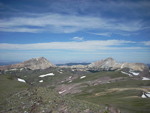
(18Aug2007-1544) The view south from North Tent, south summit, just 9 minutes and 600 mostly level feet later.
Upon close observation the causal viewer will see Amanda’s head at bottom center.
See also the next areas to which we are headed, starting with Amanda as reference:
--> Down the ridge to the saddle – just follow the bare spot in front of Amanda
--> Then notice that it climbs again – go straight and then bear right and follow the ridge where it curves
--> The highest part of that thing at dead center photo medium distance is the real deal at 11285.
All of this for a measly 65 foot net increase in altitude.
Does anyone perchance notice any false summits out there in the distance????
There are in fact 2. We tried not to notice. (18Aug2007-1655) We made it. This is the first of several shots of various of us at the top of South Tent.
In this frame, James ponders the summit features - A cairn, 2 Benchmarks and a register. James and Amanda got here at least 20-30 minutes before I did.
I do not recall which of our summit rituals (see later note on) we had or had not conducted when I took this,
so maybe some other time can be subtracted from travel time.
Still not bad for hammering a very nice ridge hike. We are still only 2 hours into the trip.
The Summit rituals (in what ever order occurs to us at the time):
(1) Engage in jubilant high-fiving, group-hugging and "we-rock"-ing as desired.
(2) Using water bottle, pour small amount of water on summit cairn or bench mark. Reason for this uncertain, but we always do it.
(3) Using GPS, store exact Lat/Long or UTM coordinates of actual summit, also make paper note of GPS altitude reading.
(4) Using camera, photodocument at least one of following:
(4.1) The summit cairn/register/benchmark
(4.2) Permutations of portions of summit team beside cairn, taken by one member not shown or, when possible, entire team with self-timer of camera on tripod or wedged among rocks, trees, or foliage.
(4.3) Panoramae of surrounding terrain from summit
(5) Eat lunch or other traditional/experimental foodstuffs (granny smith, bagels, dried cranberry), Chat, rest, extend jubilation as needed.
(6) Keep eye on weather and daylight and get-the-heck off as appropriate.
Optional additions
- Welcome slower stragglers to summit location with repeat of (1) as necessary
- While chatting, wax sentimental/philosophical regarding beauties of nature, joy of expoloration as desired

(18Aug2007-1656)
Amanda resting on South Tent summit. I think we ate, poured water, took pictures and looked around. Note clouds on all these pictures. By the time we got way up here it turned out to be very fine weather.
Amanda’s boot tread design not shown. Vibram is doing some pretty zany stuff with tread design lately.
No one knows why. (Boredom, perhaps?)We have come to refer to this as "Tread Design as Art"


There are two separate US Govt survey benchmarks on this summit. This compensates for the lack of such on the North Tent summit, we suppose. This is an image taken on our prior trip on 28Jul2007.


(18Aug2007-1735) Still on South Tent - 40 minutes later. We could not get enough of it. What a great day. And here we go with the permutated photographs. First, James and Amanda. Notice that this summit is not horribly rugged. Other parts of the mountain get into that but not this part. Wooded summit complete with trees as shown, so not exactly a towering granite pinnacle.
(18Aug2007-1736)
Amanda behind the lens, James and self in front.
James looks to be either about to yawn or sneeze. We disregard whatever foreign object partially covers bottom of image.(18Aug2007-1737)
James on the camera, another foreign object mildly in front, Self and Amanda with smiles of quiet contentment and comeradery and thumbs skyward.

(18Aug2007-1738)
James at STM summit a minute later, contemplating the mysteries of the universe.


(18Aug2007-1752)
Overview of the descent route - just before dropping from the ridge.
There was no need to revisit North Tent, so we just dropped from the saddle to about 10600 feet and contoured to the right (north)
and back to the road - shown at center with some squinting.

(18Aug2007-1946)
South Tent Mountain from Skyline Drive after descent.
We left the ridge shown at extreme left. This is 1 hour 40 minutes later, so we are probably part way up the road towards
Reeder Canyon grade.
(18Aug2007-1947)
One last view of South Tent summit from Skyline Drive on the way back to the car.
Only five hours for the whole trip. We are just about to hike the tedious part in the dusk.