What this post might have consisted of had we not been interupted
by vehicle mechanical issues was a report of a trip to Fish Lake and then Bluebell Knoll.
As it was we did not get to either place - at least under our own power.
We did get a short glance of part of Fish Lake when the tow vehicle went up
there to pick up a second vehicle for tow back to Richfield.
Here is all we will see of Fish Lake until next season:


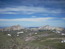
The summit we were planning on was Fish Lake High Top (elevation 11633)
To get up there, we planned hike up past here --->
The paved highway shown in the foreground is Utah Hwy 25, which is 7 miles long and
connects Fish Lake with Utah Hwy 24.
Our 2005 Safari developed a sudden leak in the oil cooler line almost exactly at the intersection of the highways and sprayed all our crank case oil all over Hwy 24 just as we were to have turned, so we overshot the turnoff by about 1 mile. Had we not missed our turnoff, we presumably would have lost our oil during the first mile of Hwy 25.
The turnoff is on an uphill grade along Utah 24 anyway, so we would have been on a strong uphill grade either way. So, The rest of the day was spent ....
..... Being towed 31 miles to Richfield
..... Finding a repair place
..... Finding a new oil cooler line
..... Getting the line replaced in time to head back to Salt Lake for the day.
We have been having screwy mechanical issues with our 2005 van all summer long;
This is a little disturbing because it was supposed to be our strong vehicle. Oh well
While we are on the topic mangled trips, here are some shots of Aspen Grove trail on Timpanogos
This was a missed summit attempt with Amanda. Check out the pretty waterfall.

The original idea was an offer to Amanda to help her try out an overnight pack trip to Timpanogos Summit via the
American Fork (Timpooneke) trailhead. I got spooked in the face of the trip launch complications and started us in Aspen Grove instead.
Don't anyone else try this at home....
The terrain is all just like what you see in front of you for about 4 miles and it is "all or nothing"
with no place up trail to put a tent. That's why no one does Aspen Grove as a 2 day, and why American Fork trail is sometimes done as a 2 day - there are more level spots spread along the route.
Amanda gets a rain check for this trip. She tells me that the messed up trip was nevertheless very productive as a guage of her own capabilities on equipment carries, terrain evaluation, site selection, night hiking, and rugged minimalist camping. She claims she had a blast and wants to have another go. Hence the rain check.
Here are two shots she had me take from our highest uphill travel point. This is actually a 2 part pan shot, from left to right. 


This is further illustration of suitability of Aspen Grove for an overnight unless Emerald Lake is where the overnight stop is. This is all straight up: 4850 feet in 5 miles According to the topo map, the straight line distance is only about 2 miles, not counting contours.
The contours in this case are close together, meaning steep terrain and therefore switchbacks. So the actual trail distance is 4 miles in switchbacks to bring the entire route total to 7 miles from Aspen Grove to summit.
The American Fork side is longer by map, but is also more level, so there are many more places to stop over. We have tried this before and it works.
So much for messed up trips this season.....
Even with that we managed to get out a bit this summer:
(1) Catherine Pass hike, Dad alone, 14 June
(2) Willard Basin/ Willard Peak recon trip, Dad alone, 5-6 July
(3) Sunset Peak and Catherine Pass, Dad/Amanda, Mom/Melissa at Lake Mary, 21 July
(4) South Tent summit, Dad and Amanda, 28 July
(5) South Tent summit, Dad, James, Amanda, (Mom, Marilyn at trailhead) 18 August
(6) Bluebell Knoll summit, Mom and Dad, 21 August
Possible trip list for other seasons:
Incomplete first ascents:
(1) Willard Peak - (Weber county)
(2) Fish Lake High Top (Sevier county)
(3) Eccentric Peak (Daggett/Uintah) - Accessible from Spirit Lake
(4) Boxelder Peak - Wasatch front
(5) Bull Mountain (Boxelder)
Possible repeats:
(1) Timpanogos 2 day - Amanda
(2) Mount Nebo (Utah county) - Dad
(3) Bluebell Knoll (Wayne county) - James/Marilyn
No comments:
Post a Comment