The Joshua R Clark family history conference was held on 25 September 2008 @ 1900-2100.
DDadson is on the planning committee, and also gave a presentation on the Wales quaker roots of Edwin D Woolley.
Various of you may have heard of this collection of stories and tidbits. A few of us have actually been to Wales. We are reluctant to beat it to death, however.
There will soon be a JoshuaRClarkFamily organization web site:
The URL is http://www.jrclarkfamily.org/
Another Clark family person - Stephen Clark in Livermore CA - is now the webmaster.
Check it out.
27 September, 2008
25 September, 2008
Nerdy trivia on 2008 hiking season
Most of this post is "read at the risk of your own boredom".....
The opera singing may be about to conclude on the 2008 outdoor crazy season....
OK - Make that Concluded. Fall has fell, White stuff litters the high country, and other activities approach...
See you all next year ... presuming there is one....
The counties of Utah summit exploration pastime included some revisits and some new items....
Some annoying tallies so far:
What happens when we get there ... the summit rituals .....
The summit rituals (in whatever order we deem applicable at the time) consist of:
(0) Arrive at the identifiable summit mark device - choices are Benchmark/Cairn/Register - or verify with GPS.
(1) Engage in jubilation - high-fives, group hugs, or other self-congratulatory expressions - as appropriate.
(2) Using water bottle, pour water on summit cairn or bench mark. Origin uncertain, but nevertheless customry.
(3) Using GPS, store exact Lat/Long or UTM coordinates of actual summit; record GPS altitude reading.
(4) Using camera, photodocument the visit as follows:
(--.1) The summit cairn/register/benchmark
(--.2) The summit team at the summit marker(s) - Permutations of summit team, taken by one member not shown
or entire team with self-timer of camera when possible.
(--.3) Horizon panoramae from summit.
(5) Eat lunch or other traditional/experimental foodstuffs (granny smith, bagels, dried cranberry), Chat, rest, extend jubilation as needed.
(6) engage in Optional extensions as desired
(7) Keep eye on weather and daylight and get-the-heck off as appropriate.
Optional Extensions:
(6.1) Welcome of slower stragglers to summit location using step (1) as necessary.
(6.2) Metaphysical conversations re grandeur of terrain, goodness of life, joy of discovery
(6.3) Discussion of descent routes.
Comments in re the above:
Item (0) is the essential pre-requisite item for being able to claim a summit visit, according to many, including us.
It is hence included in our rituals.
The technicality issue we currently have with Willard Peak is that item (0) verification could not be completed for safety reasons - no official summit verifier contacted.
We only got items 1, 4.3 and 7 completed prior to the noted T-Storm near-miss.
Finally, some really annoying lists ..... Only a hike fanatic could survive this next part - read at your own risk...
Annoying specifics on where we have been so far:
What is left to do in Utah (rough order of difficulty/probability):
Other unresolved issues:
Box Elder Peak - 11101' - Dad/James/Amanda
Mount Nebo - 11928' - Dad
Thats all, folks....
The opera singing may be about to conclude on the 2008 outdoor crazy season....
OK - Make that Concluded. Fall has fell, White stuff litters the high country, and other activities approach...
See you all next year ... presuming there is one....
The counties of Utah summit exploration pastime included some revisits and some new items....
| Summit | Alt/County | What/When | Who |
| Fish Lake High Top | 11633 / Sevier | First / 2008.07.25 | Dad/James |
| Blue Bell Knoll | 11322 / Wayne | Redo / 2008.07.26 | Dad/James/Marilyn |
| Pink Cliffs (Line) | 10080 / Kane | First / 2008.08.22 | Dad/James |
| Andy Nelson peak | 10028 / Kane | Redo / 2008.08.23 | Dad/James/Melissa/Joshua/Amanda/German |
| Willard Peak | 09763 / Weber | Technicality/ 2008.09.20 | Amanda (official summit mark not contacted) |
Some annoying tallies so far:
| Counties | Summits/Highpoints | |
Confirmed Visits by one or more of us: | 16 | 15 |
Unconfirmed Visits by one or more of us : | 1 | 1 |
Remaining to Visit: | 12 | 10 |
Total for Utah: | 29 | 26 |
What happens when we get there ... the summit rituals .....
The summit rituals (in whatever order we deem applicable at the time) consist of:
(0) Arrive at the identifiable summit mark device - choices are Benchmark/Cairn/Register - or verify with GPS.
(1) Engage in jubilation - high-fives, group hugs, or other self-congratulatory expressions - as appropriate.
(2) Using water bottle, pour water on summit cairn or bench mark. Origin uncertain, but nevertheless customry.
(3) Using GPS, store exact Lat/Long or UTM coordinates of actual summit; record GPS altitude reading.
(4) Using camera, photodocument the visit as follows:
(--.1) The summit cairn/register/benchmark
(--.2) The summit team at the summit marker(s) - Permutations of summit team, taken by one member not shown
or entire team with self-timer of camera when possible.
(--.3) Horizon panoramae from summit.
(5) Eat lunch or other traditional/experimental foodstuffs (granny smith, bagels, dried cranberry), Chat, rest, extend jubilation as needed.
(6) engage in Optional extensions as desired
(7) Keep eye on weather and daylight and get-the-heck off as appropriate.
Optional Extensions:
(6.1) Welcome of slower stragglers to summit location using step (1) as necessary.
(6.2) Metaphysical conversations re grandeur of terrain, goodness of life, joy of discovery
(6.3) Discussion of descent routes.
Comments in re the above:
Item (0) is the essential pre-requisite item for being able to claim a summit visit, according to many, including us.
It is hence included in our rituals.
The technicality issue we currently have with Willard Peak is that item (0) verification could not be completed for safety reasons - no official summit verifier contacted.
We only got items 1, 4.3 and 7 completed prior to the noted T-Storm near-miss.
Finally, some really annoying lists ..... Only a hike fanatic could survive this next part - read at your own risk...
Annoying specifics on where we have been so far:
| Summit | Alt | County | Notes | |
| AmericanForkTwinPk | 11489 | Salt Lake | 19xx-BC/J2/JG/AC | |
| KingsPk | 13528 | Duchesne | 19xx-BC/JG/J2 | |
| NaomiPk | 09979 | Cache | 2001-BC/J2/AC | |
| BridgerPk | 09255 | Rich | 2001-BC/J2/AC | |
| ThurstonPk | 09706 | Davis/Morgan | 200x-BC/J2 | |
| Deseret Pk | 11031 | Tooele | 200x-BC/J2 | |
| Cardwell(&Liner) | 10743/10840 | Wasatch | 200x-BC/J2 | |
| Monument Pk | 10452 | Carbon | 2005-BC/GC/J2/JGJ | |
| EastMountain | 10743 | Emery | 2005-BC/J2 | |
| AndyNelson(+Liner) | 10028/10080 | Kane | 2005-BC/J2/MH/JG/AC | |
| Brian Head Pk | 11307 | Iron | 2005-BC/J2/MN/AC | |
| Mt Nebo | 11928 | Utah | 2006-J2 | |
| SouthTentMtn | 11285 | Sanpete | 2007-BC/J2/AC | |
| BlueBell Knoll | 11328 | Wayne | 2007-BC/GCJ2/MN | |
| FishLakeHighTop | 11633 | Sevier | 2008-BC/J2 | |
| *Willard Pk | 9764 | Weber | 2008-AC |
What is left to do in Utah (rough order of difficulty/probability):
| Summit | Alt | County | Notes |
| Willard Peak | 9763 | Weber | Prime candidate for May-June 2009 for confirm of official summit - DayHike |
| Delano Peak | 12173 | Beaver/Piute | Tushar Range nr Beaver - moderate - Car camp overnight at 10K |
| Mount Peale | 12721 | SanJuan | La Sal range nr Moab - moderate (LaSal Pass) - overnight @ Moab |
| Bull Mtn | 09920 | Boxelder | Raft River range NW Utah - huge 4WD trip - easy walk - no overnight |
| Signal Peak | 10365 | Washington | Pine Valley range nr St George - long hike - Ovrenight car camp - Reunion possibility |
| Mine Camp Peak | 10222 | Millard | nr Fillmore/Richfield - Huge 4WD trip - short hike - Overnight in Richfield |
| Benchmark Eccentric | 12276 | Uintah/Daggett | Uinta range nr Spirit Lake - moderate if we do Spirit Lake again |
| Gilbert Peak | 13442 | Summit | Henrys Fork nr Kings Peak - anyone for a 4 day 26 mile pack trip? |
| Mount Waas | 12331 | Grand | nr Moab - LaSal range - still trying to research the access route |
| Mount Ellen | 11522 | Garfield | Henry range nr Canyonlands ... extreme middle of nowhere - long hike |
| Ibapah Peak | 12087 | Juab | nr Nevada border .... absolute middle of nowhere - huge hike |
Other unresolved issues:
Box Elder Peak - 11101' - Dad/James/Amanda
Mount Nebo - 11928' - Dad
Thats all, folks....
22 September, 2008
West Jordan recons Willard Peak
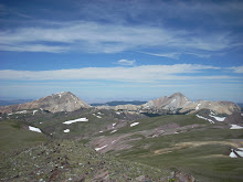
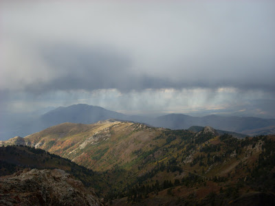
Willard Peak is the top of that ugly looking group of foothills we pass on I-15 between North Ogden and Brigham City, typically on the way to Logan. The easiest way to get withing walking distance of it is a road that goes south out of Mantua - the little town by the lake that we also pass on the way to Logan. So we keep going up there because it is pretty and we are very curious. Here is our most recent trip. We are not entirely sure what we are showing here, because the weather was marginal and we had to leave to minimize some risks. Amanda was the point person and hence the only one this high on the peak. She took the pictures and she was fortunate to get even these. We think this spot is definitely part of the formation containing the summit of Willard Peak (9763'); Amanda did not have time to verify the location of the official summit (cairn / benchmark); Neither was visible from where she is standing. The following 4 images are a panorama series from Amanda's point of highest ascent.
Pictures follow (below) captions.
(1) Looking south, including Ben Lomond peak in the distance. The outcrop in the mid foreground might actually be a bit higher and maybe contain the benchmark. Note the heavens gathering blackness.
 (2) Looking southwest and what would be a spectacular view of the Wasatch Front valleys... Except for the dark clouds which are why our explorer vacated this location soon after these were taken. This is as close to a T-storm incident as she ever plans to get.
 (3) Looking Northwest, and showing the easier of the two ridge routes. Amanda came up from the northeast using a more exposed route she did not like after using it.
 (4) Looking north into Willard Basin. The brown ribbon on the hillside at right is the dirt road used to get here. This is the end of the high panorama.
 And finally, Amanda, in subdued pose, immediately following descent from the top, taken from DDadson point of highest excursion. The weather was too cruddy for much jubilation, even though she got her mountain fix, such as it was.
 So.... We think we will take what we got and be appreciative.... We have now thoroughly scouted this route, and picked up on the missed items from last exploration. We now have all the route info we need to return for a more formal putting away of this one .... Also, it was a lovely 10 miler overall during which Dad ditched some pounds and we both looked at pretty fall leaves..... But Dad did not hit the official top - further ascent above this 9640' point was discontinued in the interest of T-storm safety - so alas HE has to come back, and it will probably be mildly irksome for the time being until this yet other score is settled. There are ironies here: The place Amanda got to (~9760) is probably good enough for her (she got there), but not for DDadson, the closure freak (mainly because he did not get there). We just may be Clarks .....This area is becoming very familiar indeed to DDadson and is even a serious candidate for a further solo trip, assuming it just has to be that way owing to scheduling of others .... The weather and schedules are getting complicated, so much as some of us would like to have it over with, it just may have to wait until the next consistent good weather in snow free high elevation, maybe meaning next season. I hope that's not what this means, but I am afraid it is. Dang. (I hiked my head off, I lost a water bottle, the weather yelled at me....).
Pictures follow (below) captions.
(1) Looking south, including Ben Lomond peak in the distance. The outcrop in the mid foreground might actually be a bit higher and maybe contain the benchmark. Note the heavens gathering blackness.
(2) Looking southwest and what would be a spectacular view of the Wasatch Front valleys... Except for the dark clouds which are why our explorer vacated this location soon after these were taken. This is as close to a T-storm incident as she ever plans to get.(3) Looking Northwest, and showing the easier of the two ridge routes. Amanda came up from the northeast using a more exposed route she did not like after using it. (4) Looking north into Willard Basin. The brown ribbon on the hillside at right is the dirt road used to get here. This is the end of the high panorama. And finally, Amanda, in subdued pose, immediately following descent from the top, taken from DDadson point of highest excursion. The weather was too cruddy for much jubilation, even though she got her mountain fix, such as it was. So.... We think we will take what we got and be appreciative.... We have now thoroughly scouted this route, and picked up on the missed items from last exploration. We now have all the route info we need to return for a more formal putting away of this one .... Also, it was a lovely 10 miler overall during which Dad ditched some pounds and we both looked at pretty fall leaves..... But Dad did not hit the official top - further ascent above this 9640' point was discontinued in the interest of T-storm safety - so alas HE has to come back, and it will probably be mildly irksome for the time being until this yet other score is settled. There are ironies here: The place Amanda got to (~9760) is probably good enough for her (she got there), but not for DDadson, the closure freak (mainly because he did not get there). We just may be Clarks .....This area is becoming very familiar indeed to DDadson and is even a serious candidate for a further solo trip, assuming it just has to be that way owing to scheduling of others .... The weather and schedules are getting complicated, so much as some of us would like to have it over with, it just may have to wait until the next consistent good weather in snow free high elevation, maybe meaning next season. I hope that's not what this means, but I am afraid it is. Dang. (I hiked my head off, I lost a water bottle, the weather yelled at me....).
Subscribe to:
Posts (Atom)