26 July, 2008

West Jordan hike at Fish Lake High Top

Here we go again ... Comrade father, having no adorable tiny children antics to display, has to improvise and is recently discovered yet again in the midst of certifiable obsession with outdoor exploring; Drags any available family members along. Any time any of you want to go crazy, the offer still stands, you know where geezer is.....


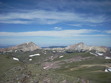
This picture series shows what it looks like in the High Plateau country east of US 89 near Richfield.
There are about 3 or 4 of these high plateau style mountains in this region. Their tops are usually 11000+ elevation
with sizable surface areas at the elevation, and one or more additional hills rising from the plateau, one of which
is the absolute summit (highest point) of the entire plateau.

The ones we have visited in this area are Fish Lake High Top, Boulder Mountain (home of BlueBell Knoll); there is another one between Fish Lake and Boulder Top, I believe.
This series is of the Fish Lake High Top plateau (summit elevation 11633) just above Fish Lake.

Frame below is about halfway up the customary foot route which starts at one of the Fish Lake overlooks
(Pelican Point); the canyon forks here and we are headed up the North fork, shown ahead. The rim is in the distance above.

Frame below is on the top of the plateau, looking toward the final 100' high hill which contains the highest actual elevation on the plateau - the actual high point is the top of a house size boulder.Frame below is from the top of the exact highpoint boulder looking into the distance. Various trail notes and advisories say to find "the" house-sized boulder, but there are about 50-100 such large boulders up here, so it becomes a "which one" issue very quickly. Some surrounding boulders and the plateau are in the foreground.
This is another view from the summit hill, showing the plateau and looking towards Pelican canyon trail


Now a video from enroute across the plateau shown in foreground above on my way down


This is really mostly intended as a sample of what kind of outdoor country there is in south central Utah.
You almost cannot tell the difference between downstate and Salt Lake from this, but if you go to the lower
elevations in the vicinity of this, it is drier.

24 July, 2008

West Jordan at Aunt Eleanor Birthday party

There was a surprise party in Orem for Aunt Eleanor Jorgensen on 24 July at the Washburn place. Various of the Jorgensen cousins contacted us. Aunt Eleanor, Uncle Cecil, and a goodly number of north Utah and Colorado
Jorgensen relatives in attendance: RI Jorgensen branch (Jerry, Steve, Mike, Jeff), Brown branch (Jared, George), and JR Clark (Bruce, Don Bragg). Also assorted progeny. Lunch and some hanging out before the group dispersed again.

Also we learned that Jared (Brown) has succeeded in getting a key family artifact back in the family: the Lion carried by to Utah by Mary Williamson (Mormon Martin company handcart survivor). This Lion figure has been talked about in family history in connection with the Mary Williamson story for years, but only Aunt Eleanor and Uncle Cecil had ever seen it. It has been a few places since 1858...
Mary Williamson and William Barton were parents of Amanda Barton Horsley, Florence V Jorgensen's mother.
The Lion went to Amanda Horsley and then to various Horsley family members and finally to some Horsley relatives in Montana who probably did not have much interest in most of the story other than it being an heirloom of some kind.
Jared was able to talk them into selling it. The plan is to place it for public display.
Lion figure, left side (note the screw - it is original, the figure is in two halves)
Lion figure, right side


Jerry Washburn holding lion figure
Jared/Margie Brown with Aunt Eleanor/Uncle Cecil and the lion
R.I. Jorgenson group (Jerry,Stephen, Mike, Jeff) with Aunt/Uncle and the lion


20 July, 2008

Birthday hike at Brighton (mount Evergreen)

We needed something short and to the point for this mid afternoon hike to fit Dad's birthday gathering.
Mount Evergreen (9890) turned out to be a nice pick for a quick 1.5 miles from the parking lot.
We took the ski lift road from trailhead to north end of Twin Lakes Dam (.75 mi),
then TwinLakes Pass trail along the north side of Twin Lakes to the back side of Evergreen (.25 mi)
to pick up the summit ridge access which is readily accessible.
Quick bash up the rocks past one endearing false summit - we were too fast for it to move
and there you go (.25 mi). Dad scouted this little gem alone last season.
None of these shots are OF Evergreen but FROM Evergreen. It is visually unremarkable, sorry.
We were thinking of the Arizona crew all the way up. Joshua has been all over this stuff too, remember.
Just stroll down memory lane if desired. Anyway here you go.
(1) Smiling faces of the happy summit team. We are much pleased with our self timer..

Now a video pan of what can be seen from where we are

Now 3 stills comprising the self same pan therein thereof ....
(2) South East to Milicent/Pioneer/Sunset Peak/Lake Mary area uphill from Brighton

(3) East across the bowl to Clayton Peak.
(4) North East toward Scott's Hill and Guardsman area.


Some more stills for continuing nostalgia....
(5) On the descent - South across Twin Lake to Millicent/Wolverine/Tuscarora

(6) On the descent - Twin Lake Dam and adjacent lake


Ye Summit Riff - 1

Ye Summit Riff - 2

Ye Summit Riff - 3