This picture series shows what it looks like in the High Plateau country east of US 89 near Richfield.
There are about 3 or 4 of these high plateau style mountains in this region. Their tops are usually 11000+ elevation
with sizable surface areas at the elevation, and one or more additional hills rising from the plateau, one of which
is the absolute summit (highest point) of the entire plateau.
The ones we have visited in this area are Fish Lake High Top, Boulder Mountain (home of BlueBell Knoll); there is another one between Fish Lake and Boulder Top, I believe.
This series is of the Fish Lake High Top plateau (summit elevation 11633) just above Fish Lake.
Frame below is about halfway up the customary foot route which starts at one of the Fish Lake overlooks
(Pelican Point); the canyon forks here and we are headed up the North fork, shown ahead. The rim is in the distance above.
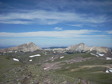
 Frame below is on the top of the plateau, looking toward the final 100' high hill which contains the highest actual elevation on the plateau - the actual high point is the top of a house size boulder.
 Frame below is from the top of the exact highpoint boulder looking into the distance. Various trail notes and advisories say to find "the" house-sized boulder, but there are about 50-100 such large boulders up here, so it becomes a "which one" issue very quickly. Some surrounding boulders and the plateau are in the foreground.
 This is another view from the summit hill, showing the plateau and looking towards Pelican canyon trail
Now a video from enroute across the plateau shown in foreground above on my way down
This is really mostly intended as a sample of what kind of outdoor country there is in south central Utah.
You almost cannot tell the difference between downstate and Salt Lake from this, but if you go to the lower
elevations in the vicinity of this, it is drier.
No comments:
Post a Comment