Pictures follow (below) captions.
(1) Looking south, including Ben Lomond peak in the distance. The outcrop in the mid foreground might actually be a bit higher and maybe contain the benchmark. Note the heavens gathering blackness.
 (2) Looking southwest and what would be a spectacular view of the Wasatch Front valleys... Except for the dark clouds which are why our explorer vacated this location soon after these were taken. This is as close to a T-storm incident as she ever plans to get.
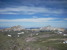
 (3) Looking Northwest, and showing the easier of the two ridge routes. Amanda came up from the northeast using a more exposed route she did not like after using it.
 (4) Looking north into Willard Basin. The brown ribbon on the hillside at right is the dirt road used to get here. This is the end of the high panorama.
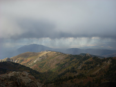 And finally, Amanda, in subdued pose, immediately following descent from the top, taken from DDadson point of highest excursion. The weather was too cruddy for much jubilation, even though she got her mountain fix, such as it was.
  So.... We think we will take what we got and be appreciative.... We have now thoroughly scouted this route, and picked up on the missed items from last exploration. We now have all the route info we need to return for a more formal putting away of this one .... Also, it was a lovely 10 miler overall during which Dad ditched some pounds and we both looked at pretty fall leaves..... But Dad did not hit the official top - further ascent above this 9640' point was discontinued in the interest of T-storm safety - so alas HE has to come back, and it will probably be mildly irksome for the time being until this yet other score is settled. There are ironies here: The place Amanda got to (~9760) is probably good enough for her (she got there), but not for DDadson, the closure freak (mainly because he did not get there). We just may be Clarks .....This area is becoming very familiar indeed to DDadson and is even a serious candidate for a further solo trip, assuming it just has to be that way owing to scheduling of others .... The weather and schedules are getting complicated, so much as some of us would like to have it over with, it just may have to wait until the next consistent good weather in snow free high elevation, maybe meaning next season. I hope that's not what this means, but I am afraid it is. Dang. (I hiked my head off, I lost a water bottle, the weather yelled at me....).
No comments:
Post a Comment